
GraniteNet Software
ESRI ArcGIS Integration
 |
 |
GraniteNet offers FULL ESRI ArcGIS INTEGRATION
 |
- ESRI Integration allows bi-directional integration with ESRI's ArcGIS Software using either the ArcObjects Framework, or the ArcGIS Runtime SDK for .NET.
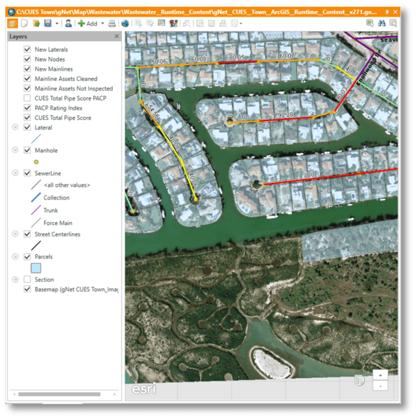
- GraniteNet allows end-users to import and export asset data, export Inspection Observations, and export pipeline inspection scores to/from an ArcGIS 10.x system (shape files, personal geo-database, File Geodatabase, or SDE) utilizing the network features and precision factor to associate Sewer, Storm or combined Mains with corresponding Node and Lateral assets.
- GraniteNet also has a MapView module which allows end-users to display the ArcGIS Map with wide capabilities to navigate to/from GraniteNet objects and also start the tasks from the map.
DOWNLOAD THE ESRI / GRANITENET BROCHURE
GraniteNet also provides an optional interface for select GPS devices which supporting the required NMEA standard. We offer one of these models as a part of two different kits we sell. To view details about our Mapping Stick package, click here. To view details about our Mapping Backpack package, click here.
Interested in Learning More? |
||
| ABOUT US | CONTACT US | |
| CUES is a multifaceted organization engaged in robotic R&D, new product design and engineering, hardware manufacturing, vehicle assembly, software engineering, professional services consulting, sales, training and dedicated customer support. The company has evolved, driven by the needs of its customers who demand to have one, responsive company be the focal point for all of their wastewater, stormwater, and water management needs. | 3600 Rio Vista Avenue, Orlando, Florida 32805 Phone: (407) 849-0190 Toll Free: (800) 327-7791 Fax: (407) 425-1569 Email: salesinfo@cuesinc.com |
|
| OUR PARTNERS | ||
 |
 |