
GraniteNet

Patented Technology! Wirelessly capture GPS coordinates for your Sewer and Stormwater structures to precisely document their location and underground paths.
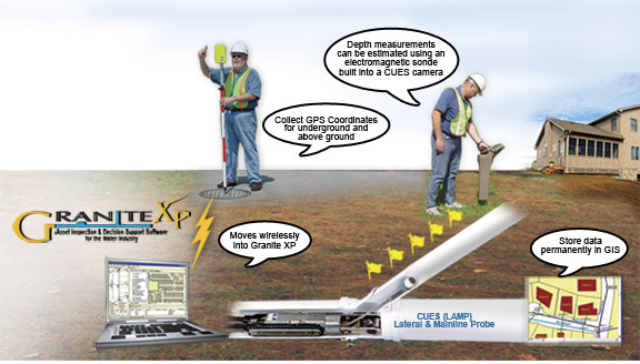 |
Used in conjunction with GraniteNet (or Granite XP) and the CUES LAMP (Lateral & Mainline Probe), the Wireless GPS Mapping Stick is designed to precisely locate structures such as manholes and collect sub-meter accurate GPS coordinates and transmit them seamlessly into GraniteNet (or Granite XP) inspection software from a distance of up to 1500 feet.
The Wireless GPS Mapping Stick features include the ability to obtain the current coordinates of the Sewer, Storm, Fiber, and Gas Pipeline segments, including Nodes, Main and Lateral Assets. Tracing the path of lines can also be precisely recorded and updated into GIS maps to present detailed infrastructure layers as well as linear references. The GPS data is easily associated to the specific asset identified in the field and then updated into GIS. Field crews can immediately see the captured locations appear in the map, including line traces, to verify their work. This tool, when combined with a sonde locator, can provide the coordinates and line traces for Lateral Service Connections. The kit includes a Trimble™ ProXT receiver.
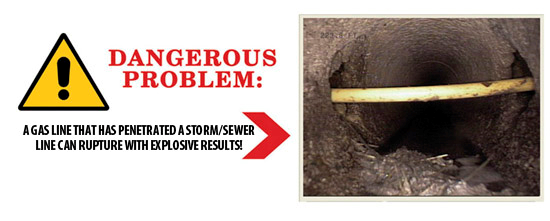
Crossbore Dangers:
CUES cares about safety and education regarding crossbore issues. There are multiple technologies available today which can improve safety and reduce risk associated with drilling and boring. Although serious injury and death has occurred as a result of improper installation of gas utility lines, the industry must identify the optimal combination of tools which can provide the greatest yield on safety.
The patented* Wireless GPS Mapping Stick enables utilities to accurately mark their lines, including lateral service connections. NASTT definition of a cross bore: “A utility cross bore is an intersection of an existing underground utility or underground structure by a second utility resulting in direct contact between the transections of the utilities that compromises the integrity of either utility or underground structure.”
* U.S. Patent No. 7,889,124
WIRELESS GPS MAPPING STICK BROCHURE
To learn more about the Wireless GPS Mapping Stick and how it can prevent tragedies and save lives, contact CUES.
 |
Interested in Learning More? |
||
| ABOUT US | CONTACT US | |
| CUES is a multifaceted organization engaged in robotic R&D, new product design and engineering, hardware manufacturing, vehicle assembly, software engineering, professional services consulting, sales, training and dedicated customer support. The company has evolved, driven by the needs of its customers who demand to have one, responsive company be the focal point for all of their wastewater, stormwater, and water management needs. | 3600 Rio Vista Avenue, Orlando, Florida 32805 Phone: (407) 849-0190 Toll Free: (800) 327-7791 Fax: (407) 425-1569 Email: salesinfo@cuesinc.com |
|
| OUR PARTNERS | ||
 |
 |